2001 – 2003
2001 – 2003
A Dating Framework for the Lower and Middle Palaeolithic of Syria: Terraces and Sediments of the River Orontes
[Funded by the Council for British Research in the Levant]
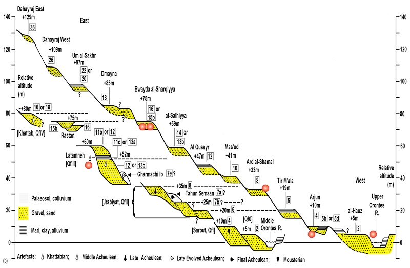
Geological and geomorphological mapping in the Homs region of Syria has revealed a staircase of at least 11 terraces of the upper Orontes River. River terraces have previously been recognised only in the middle and lower parts of this system where, at some localities, they have yielded Palaeolithic artefacts and mammalian fauna. Around Homs, where the terrace deposits overlie Pliocene marl bedrock, they have been calcareously cemented into conglomerates (gravels) and marls (fine-grained alluvium). The relative hardness of the conglomerates in particular has promoted their preservation and has probably led the Orontes to migrate away repeatedly from its former course and incise the bedrock further to the north-west, thus forming one of the most complete terrace staircases anywhere in the World. Modelling of the crustal uplift necessary to form this terrace system suggests that the oldest terrace dates from the Early Pleistocene (c. 1.2 Ma) and that terrace formation during the Middle and Upper Pleistocene was in approximate synchrony with Milankovitch climate change.
In the first season, in September 2001, fieldwork was concentrated to the south and east of Lake Kattineh, on the right bank of the Orontes (Fig. ##). This field area is effectively delimited to the south and west by proximity to the Lebanon border, to the north by the urban area of Homs, and to the east by a line of hills – the northward continuation of the Anti-Lebanon mountain range – which rise to ~1500 m. The WNW-ESE distance from the modern Orontes course to these hills, which bound to the ESE any conceivable former course of this river during the Pliocene or Quaternary, is up to ~15 km, the SSW-NNE extent of accessible localities being ~25 km. We estimate that the typical channel orientation, averaged over time, for this reach of the Orontes has been S20°W-N20°E and use this orientation to project the longitudinal terrace profile derived from our field observations (Fig. ###). In addition, we provide descriptions of key localities farther north, including the ~75 m terrace at Rastane at the upper end of the Middle Orontes gorge. Figure #### shows an idealised transverse profile through the terrace sequence, prepared using this field evidence. In 2001 accurate positioning was achieved by using a portable GPS receiver, which gave 8-digit grid references using the UTM system. To obtain accurate height information we located each site on available 1:25,000 scale topographic maps, which have 5 m contour intervals, and interpolated the height to the nearest metre.
During the 2002 field season a principal aim was to obtain accurate height and location data using differential GPS equipment, essential to reconstruct the 3-d form of the Orontes terraces. To this end, Leica equipment belonging to the Geography Department at Durham was taken to Syria. This equipment, which generally provided height data that was accurate to the nearest 0.1-0.5m at the 66% confidence level, was supplemented by use of a hand-held GPS with inbuilt aneroid barometer, provided by RW.
The Leica equipment comprised duplicate satellite monitoring devices, one of which was set up with its antenna on the roof of the house in Homs, with clear vision of the sky, to act as an immobile base station. During fieldwork periods his unit was permanently connected to mains power through the battery charger, which was also used at night to charge the two battery packs. The 2nd (rover) unit was taken to the various sites to be recorded, from which the GPS satellites were monitored over a minimum of 3 minutes (usually >90 epochs at 2 second intervals). This rover unit, which required battery power, had its antenna attached to a wooden pole at fixed height above head & vehicle level. At the end of each recording period data, from the base and rover units were downloaded and compared using Leica-supplied software on a laptop computer, which enabled calculation of accurate height information for the sites visited (provided that the base station was functioning at the time of the visit). Height data were calibrated with reference to a known height at the summit of a ‘tel’ on the outskirts of Homs at 523.2m above the Syrian sea-level datum.
A number of problems were encountered in using the Leica GPS, most important of which was the tendency of the base station to deactivate itself. The cause of this annoying problem has not been fully established, but it was clearly related to power problems. Despite using a UPS device, it seems that variations in the mains power caused the battery charger to cut out, leaving the base station running on remaining battery power. The battery pack used for the base station was not in good condition and lasted a relatively short time, under such circumstances, before it failed. Any rover data collected after the base station was rendered inactive in this way was useless. Although personnel in the house were aware of the problem, they were unable to restart the base station, which required a period of battery recharging, nor where they able to alert the field team of the problem, in the absence of cell phones. For all sites visited, supplementary data was obtained using the hand-held/aneroid equipment. For several sites visited only when the Leica base-station was inactive, this inferior data is all that is available from the 2002 season (despite some of these sites being visited by the rover on 2-3 occasions!). Experience with the aneroid equipment showed that, because of natural diurnal and climatic fluctuations in air pressure, it was desirable to recalibrate the equipment at a known height at frequent intervals.